FG lists Lagos, Delta, Kogi, 30 others in 2026 Flood Alert
Abiodun Folarin
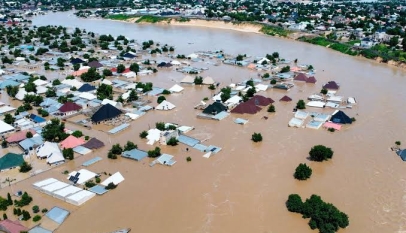
As the rainy season sets in, the Federal Government has raised fresh alarm over impending floods across Nigeria, naming Lagos, Rivers, Kogi, Delta, Bayelsa and 28 other states, alongside the Federal Capital Territory (FCT), as high-risk areas between April and November 2026.
Presenting the 2026 Annual Flood Outlook at the Presidential Villa Banquet Hall in Abuja on Wednesday, President Bola Tinubu said the report provides impact-based forecasts across the 36 states, the FCT, all 774 Local Government Areas (LGAs), and communities nationwide, sufficient to trigger preparedness, response and evacuation measures against possible flooding.
The President identified flooding as one of the major challenges confronting the nation, noting that Nigeria has faced devastating flood disasters since 2012.
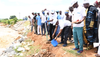
“In addressing this challenge, I confronted it head-on by initiating policy frameworks and programmes to tackle the recurrent annual floods in different parts of the country,” he said.
“Part of these programmes includes the execution of several flood control projects across the states. In addition, states identified as major flood hotspot notably Adamawa, Taraba, Benue, Borno, Yobe, Kebbi, Niger, Nasarawa, Kogi, Edo, Anambra, Delta, Bayelsa, Rivers and Cross River have received priority attention.”
Tinubu added that the country’s agricultural sector is recording steady progress.
“I am happy to inform you that yields from our agricultural sector have continued to improve, and we are becoming more food-sufficient than in the past,” he said.
He further noted that the 2024 flood incident in Maiduguri, Borno State, has prompted a shift from traditional flood response to a more proactive approach in managing floods and natural resources.
In his keynote address, the Minister of Water Resources and Sanitation, Prof. Joseph Utsev, said the forecast signals a significant threat to lives, agriculture, infrastructure and livelihoods, with thousands of communities already identified as vulnerable.
According to the report, about 14,118 communities across 266 LGAs in 33 states and the FCT fall within the high flood risk category. The affected states include Abia, Adamawa, Anambra, Bauchi, Bayelsa, Benue, Borno, Cross River, Delta, Ebonyi, Edo, Enugu, Gombe, Imo, Jigawa, Kaduna, Kano, Kebbi, Kogi, Kwara, Lagos, Nasarawa, Niger, Ogun, Ondo, Osun, Oyo, Plateau, Rivers, Sokoto, Taraba, Yobe and Zamfara.
The outlook further indicates that 15,597 communities in 405 LGAs across 35 states excluding Ekiti will face moderate flood risk, while 923 communities in 77 LGAs across 24 states are projected to experience low flood incidents.
A breakdown of the seasonal pattern shows that flood intensity will vary throughout the year. Between April and June, about 9,021 communities in 188 LGAs are expected to experience high flood risk. This is projected to rise to 14,158 communities in 263 LGAs between July and September, before declining to 11,575 communities in 224 LGAs between October and November.
Similarly, moderate flooding is expected to affect 8,225 communities in 228 LGAs from April to June; increase to 15,621 communities in 407 LGAs between July and September; and decline to 9,263 communities in 272 LGAs towards the end of the season.
Prof. Utsev warned that high-risk floods could have severe consequences on population centres, farmlands, livestock, infrastructure and the environment, stressing the need for early preparedness and coordinated mitigation efforts.
He added that flash and urban flooding are expected in major cities due to high rainfall intensity and poor drainage management. Cities likely to be affected include Abakaliki, Abeokuta, Abuja, Asaba, Benin City, Birnin Kebbi, Calabar, Ibadan, Kaduna, Kano, Lagos, Makurdi, Nguru, Onitsha, Osogbo, Port Harcourt, Sokoto, Warri and Yola.
On coastal and riverine flooding, the minister said Bayelsa, Cross River, Delta, Lagos, Ogun, Rivers and Ondo states are at risk due to rising sea levels and tidal surges, which could impact fishing, wildlife habitats and river navigation.
He commended the Nigeria Hydrological Services Agency for producing the report, describing it as a vital planning tool for governments, stakeholders and communities.
“The Annual Flood Outlook is not just a scientific report; it is a call to action,” he said, noting that early warnings help save lives, protect livelihoods and reduce economic losses.
Utsev further highlighted ongoing efforts by the Federal Government to strengthen flood preparedness, including the modernisation of hydrological monitoring systems, deployment of automated river gauge stations, and improved data collection and modelling.
He added that collaboration with the Nigerian Meteorological Agency (NiMet), the National Emergency Management Agency (NEMA), and state emergency agencies is being strengthened to improve early warning systems and community response.
The minister stressed that smart water resource management remains central to the government’s long-term strategy, with increased use of digital technologies, geographic information systems, remote sensing and real-time monitoring to support effective flood management nationwide.